Q-ACTIVITIES
Building Blocks of the Earth: Minerals and Rocks
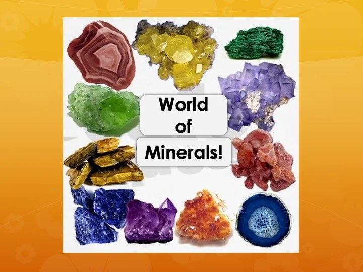
WORLD OF MINERALS
Duration: 60, 120 or 180 minutes
Academic Level: Grades 4–5, 6–8, 9–12
Overview:
Students investigate the fascinating
world of minerals using real specimens from the Quartermain
Earth Science Centre’s collection. Through a series of
inquiry-based activities, students learn to observe, test,
and classify minerals using an identification key. The
program emphasizes the practical importance of minerals in
everyday life.
What to Expect:
Following a lively, interactive
introduction, students rotate through hands-on stations in
small groups. Each station focuses on one or two key mineral
properties, such as hardness, colour, streak, or magnetism.
With the aid of self-guided worksheets and geological tools,
students conduct simple experiments and record their findings.
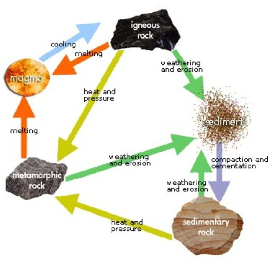
THE ROCK CYCLE
Duration: 60, 120 or 180 minutes
Academic Level: Grades 4–5, 6–8, 9–12
Overview:
Students embark on a geological journey
to explore the rock cycle using samples from the Quartermain
Earth Science Collections. By examining igneous, sedimentary,
and metamorphic rocks, students gain insight into the dynamic
processes that form and transform Earth’s crust. Topics
include volcanoes (surface and underwater), ore formation,
sedimentation, fossilization, and metamorphism.
What to Expect:
- Elementary Level – "Living the Rock Cycle": After an engaging introduction, students act out the rock cycle as they learn how each rock type is formed and changed. The activity concludes with a fun challenge to answer a scientific question using their experience.
- Middle & High School – "Stratigraphy: How Geology is Like a Murder Mystery": Students develop observation and interpretation skills by analyzing rock textures and learning the Laws of Stratigraphy. Working in small groups, they solve a geological mystery by reconstructing a rock record story.
Shake, Rattle and BOOM! Volcanoes & Earthquakes

MINING AND RESOURCES
Duration: 60, 120, or 180 minutes
Academic Level: Grades K–3, 4–6, 6–8, 9–12
Overview:
Where does our stuff come from? In this
activity, students explore the role of mineral resources in
modern life. They learn about the full mining cycle—from
discovery and extraction to environmental responsibility and
economics. Key themes include sustainable development, mine
planning, ore processing (on Earth and in space!), and the
Mine Waste Hierarchy.
What to Expect:
After a dynamic introduction to
minerals and mining, students work in small groups to plan and
operate a hypothetical mine in Canada. They are challenged to
balance ore extraction with environmental protection while
navigating economic pressures and potential penalties. For
extended sessions, the activity can be expanded to include
ore processing and the "Mining in Space" module.
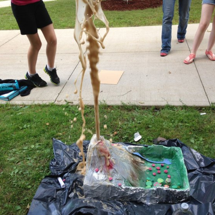
VOLCANOES
Duration: 90 or 180 minutes
Academic Level: Grades 4–8, 9–12
Overview:
What are volcanoes, and why do they
erupt? Why do people live near them despite the risks? This
activity invites students to step into the shoes of a
volcanologist, exploring the inner workings of volcanoes and
their role in shaping Earth. Students learn how volcanic
activity influences the atmosphere, radiative balance, and
land formation—while also understanding the real dangers
they can pose.
What to Expect:
Students can explore:
- The types of volcanoes (Cinder Cone, Composite, Shield) and their eruption styles.
- The hazards associated with different volcanoes (e.g. pyroclastic flows, ash, lava)
- A simulated volcanic island assessment—students evaluate the safety and suitability of establishing a new community near a volcano.

LANDSLIDES
Duration: 90 or 180 minutes
Academic Level: Grades 3–5, 6–8, 9–12
Overview:
What makes a structure safe during an
earthquake? How do engineers prevent landslides from damaging
homes and roads? This activity introduces students to the
field of Geoscience and Geological Engineering, where geology
and engineering meet to reduce natural hazards and protect
communities. Students learn how geological engineers help
create a safer and more sustainable world by applying earth
science in real-life scenarios.
What to Expect:
- Grades 3–5: After an introduction to earthquakes, students are challenged to design and test buildings that can withstand seismic shaking.
- Grades 6–8: Students explore landslide hazards and take on the role of a geological engineer tasked with protecting a community built near a slope. Working within budget constraints, they must develop cost-effective solutions to reduce risk and ensure safety.
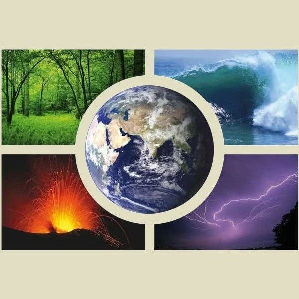
EARTH SYSTEMS
Duration: 60, 120 or 180 minutes
Academic Level: Grades 7–8, 9–12
Overview:
This hands-on, inquiry-based activity
introduces students to the dynamic interactions among Earth’s
major systems—the atmosphere, hydrosphere, geosphere, and
biosphere—while also exploring the emerging concept of the
anthroposphere, the human-made system. Designed to follow the
Energy module, this session emphasizes systems thinking and
encourages students to explore how Earth's subsystems are
interconnected through feedback loops, natural processes, and
human influences.
Drawing on real-world case studies and powerful imagery,
including astronaut photography from the International Space
Station, students investigate how Earth’s systems function
individually and collectively. This foundational activity
supports the development of scientific vocabulary, systems
modeling, and environmental reasoning, and is aligned with
curriculum goals in Earth and Climate Science.
What to Expect:
Students will engage in a mix of
indoor and outdoor investigations that focus on identifying,
describing, and modeling components of Earth’s systems.
Through guided inquiry and teamwork, they will:
- Explore the structure, behaviour, and interactions of major Earth systems.
- Analyze system interconnectivity using real-world examples, such as flooding in Fredericton or wildfires in North America.
- Build and critique conceptual or physical models of systems such as rivers, forests, volcanoes, or soil environments.
- Practice applying scientific reasoning and Earth science terminology in authentic contexts.
- Work collaboratively to solve problems, reflect on system responses to change, and connect concepts to environmental decision-making.
- Build their own Winogradsky columns in the field using local pond sediment, organic matter, and water.
- Observe how microbial communities form distinct layers based on oxygen, light, and chemical gradients.
- Document changes over time (1–3 months), including colour shifts, gas production, and microbial activity.
- Connect their observations to cycling of carbon, nitrogen, sulfur, and iron, and to feedback loops between the biosphere, geosphere, hydrosphere, and atmosphere.
- Reflect on the role of the anthroposphere and how human activities can disrupt natural cycles.

EARTHQUAKES
Duration: 90, 120, or 180 minutes
Academic Level: Grades 7–8, 9–12
Overview:
Why do earthquakes, volcanoes, and
mountain ranges occur in specific regions of the world? The
answer lies in plate tectonics—the theory that Earth’s rigid
outer shell, the lithosphere, is broken into moving plates.
Where these plates meet, we see major geological activity such
as earthquakes, volcanic eruptions, and mountain formation.
This activity helps students explore the science behind
earthquakes and understand the hazards they present, from
ground shaking and building collapse to landslides and tsunamis.
What to Expect:
Students investigate
earthquake-related processes, including ductile vs. brittle
deformation, liquefaction, stick-slip motion, and seismic wave
behaviour. Using real seismic data from earthquake-prone
regions, students are challenged to develop and test their
own models—using real seismic data, pom poms and string—
to better understand how and why earthquakes happen.

GROUNDWATER SYSTEMS
Duration: 180 minutes
Academic Level: Grades 7–8, 9–12
Overview:
Many Canadians rely on groundwater every
day, yet few fully understand what it is or how it works. In
this in-depth activity, students explore where groundwater is
stored, how it moves through different types of underground
materials, and how it can be impacted by natural events and
human activities. With growing concern over water quality,
this activity emphasizes the importance of groundwater
protection and sustainable resource management.
What to Expect:
Students use a miniature
groundwater model to explore the movement of water through
various aquifers, identify the water table, and observe
features of the hydrologic cycle. They then take on the role
of environmental scientists to investigate a contamination
event using a map of downtown Fredericton and simulated well
testing for different acidities. Students apply their findings
to identify the source of contamination, propose mitigation
and remediation strategies, and explore topics like Darcy’s
Law, contouring, and the real-world impacts of natural
disasters on groundwater systems.

PLATE TECTONICS
Duration: 90 or 180 minutes
Academic Level: Grades 7–8, 9–12
Overview:
This engaging, hands-on activity guides
students through the development of the Theory of Plate
Tectonics, tracing its evolution from the early concept of
Continental Drift to the modern understanding of Earth’s
dynamic crust. Students explore the structure of the Earth,
the scientists behind key discoveries, and the internal energy
sources that drive tectonic movement.
Building on prior knowledge from the Earth Systems module,
this session emphasizes how plate tectonics connects multiple
Earth systems. It highlights the mechanisms that shape
continents, ocean basins, mountains, and mid-ocean ridges,
offering students a foundation for understanding Earth’s
constantly changing surface.
What to Expect:
Students will participate in
interactive investigations that bring tectonic processes to
life. They will:
- Explore historical and scientific milestones in the development of plate tectonic theory.
- Investigate the Earth's internal layers and energy sources driving plate motion.
- Use real GPS data to track and visualize the movement of tectonic plates over time.
- Analyze the shapes of continents, comparing fossil records and rock types across continents to build evidence for plate movement.
- Examine surface features such as mountain ranges, ocean basins, and seafloor spreading zones, and understand their formation through tectonic processes.
Life, time, and Space

ENERGY
Duration: 60 minutes
Academic Level: Grades 7–8, 9–12
Overview:
Introduction to Earth Systems Science:
This interactive outreach activity provides students with
an engaging and inquiry-based introduction to key curriculum
concepts related to energy. Designed to support hands-on
learning and critical thinking, the session explores
foundational scientific principles, including the laws and
properties of energy, as well as the major sources of energy
on Earth—the Sun, Earth’s interior, and gravity. Students gain
insight into various forms of energy, such as thermal,
mechanical, radiative, convective, conductive, chemical, and
radioactive energy, while making real-world connections to
Earth systems and everyday life.
What to Expect:
During the session, students will
participate in hands-on experiments and real-time
demonstrations that bring energy concepts to life. They will
actively investigate how energy behaves, flows, and transforms
across systems, deepening their understanding through
observation and guided discussion. The activity encourages
students to think critically about how energy powers their
homes, communities, and the dynamic systems that shape our
planet. By the end of the session, students will have
developed a stronger grasp of both scientific concepts and
their practical implications in the world around them.

THE HYDROLOGIC CYCLE
Duration: 90, 120, or 180 minutes
Academic Level: Grades 3–5, 6–8
Overview:
What is Earth’s most precious resource?
It’s not gold or diamonds—it’s water. And most of our usable
drinking water doesn’t come from lakes or rivers—it comes
from groundwater. In this engaging, hands-on activity, students
are introduced to the hydrologic cycle and the importance of
protecting this mostly non-renewable resource for a sustainable
future.
What to Expect:
Through fun, age-appropriate play
with scarves, sand, and gravel, younger students explore key
concepts like porosity, permeability, and groundwater flow.
This foundational activity helps build early understanding of
how water moves through Earth's systems and why it matters.

SURFACE WATER STUDY
Duration: 120 or 180 minutes
Academic Level: 9–12
Overview:
This hands-on laboratory and field
activity offers high school students a meaningful opportunity
to explore surface water systems and the hydrologic cycle
through direct observation, data collection, and analysis.
After reviewing the key components of the water cycle and
surface water processes in the classroom, students head into
the field to apply their knowledge at a safe, accessible
stream or creek site.
What to Expect:
In small groups, students conduct
a comprehensive river profile, beginning with a site assessment
and a qualitative description of the stream’s characteristics
(e.g., channel shape, sediment type, vegetation, and
surrounding land use). They then gather quantitative data,
including:
- River width and depth to create a cross-sectional diagram of the stream.
- Flow rate measurements using either basic materials (such as orange peels) or a velocimeter.
- Water temperature and basic water chemistry parameters (e.g., pH, salinity, and conductivity).
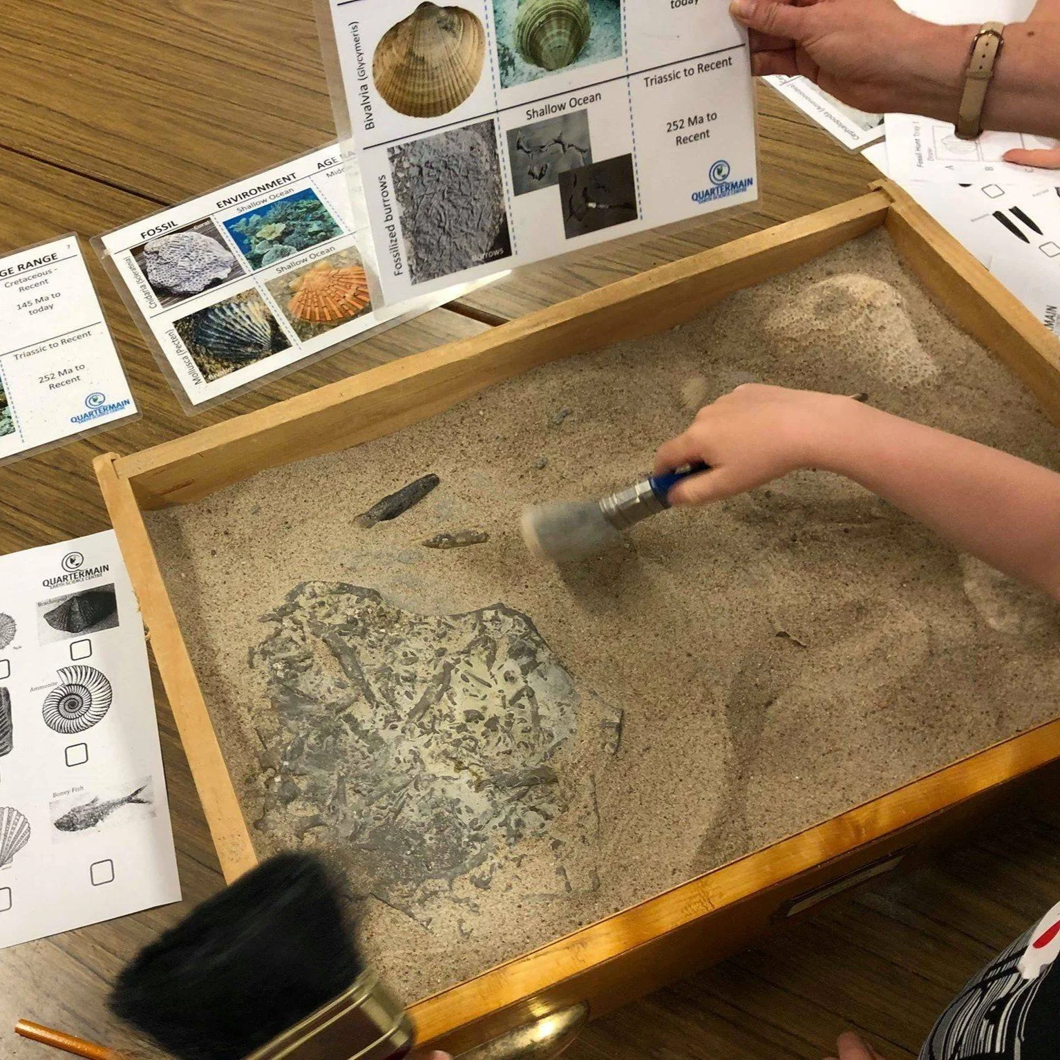
THE GREAT FOSSIL HUNT
Duration: 90 or 180 minutes
Academic Level: Grades K–3, 4–5, 6–8, 9–12
Overview:
In this engaging, hands-on activity,
students step into the role of paleontologists, using fossils
to uncover clues about Earth’s ancient past. Students learn
how fossils are formed, how they are discovered, and what
they reveal about the prehistoric organisms and environments
that once existed. They explore a variety of fossil
types—including body fossils and trace fossils—to better
understand how scientists reconstruct past ecosystems and
geologic history.
What to Expect:
Students are challenged to observe
carefully, ask scientific questions, and analyze evidence to
identify and interpret real fossil specimens. As the activity
progresses through grade levels, students work to connect
fossil findings to specific paleoenvironments and determine
the geologic age of the site. Students also have the
opportunity to create their own fossil to take home!

OPTICS AND OPTICAL MINERALOGY
Duration: 120 or 180 minutes
Academic Level: Grades 7–8, 9–12
Overview:
This engaging two-part activity
introduces students to the fundamental properties of
light—including polarization, birefringence, reflection,
refraction, fluorescence, and triboluminescence, and their
applications in the Earth sciences. Through intuitive, hands-on
experiments, students gain a foundational understanding of how
light interacts with materials, and how these principles are
applied in fiber optics and optical mineralogy.
By connecting basic optical principles to the behaviour of light
in crystals, the activity helps demystify what students observe
under a polarizing light microscope. It also lays the groundwork
for more advanced concepts such as the optical indicatrix, used
to describe the directional dependence of light velocities and
refractive indices in anisotropic minerals.
What to Expect:
Session 1 – Exploring Light, Interactive Stations: In this hands-on session, students rotate through five experiment stations, each designed to highlight a different property of light using simple, everyday materials. Activities may include:
- Investigating polarization with polarized lenses.
- Exploring refraction and birefringence using vegetable oil and transparent solids.
- Reconstructing paleoenvironments and possible behavioural scenarios based on fossil evidence.
- Observing fluorescence under UV light.
- Creating triboluminescence by crushing Life Saver mints in the dark.
- Demonstrating internal reflection using laser pointers and water-filled tubes.
Session 2 – Light and Crystals, Polarized Light Microscopy: Held at the University of New Brunswick in Fredericton or at a facility with polarized light microscopes. This session bridges classroom physics and Earth science, offering students a hands-on introduction to optical crystallography and the microscopic world of minerals. In this advanced session, students:
- Examine the components and function of a polarizing light microscope.
- Observe and analyze optical properties of minerals such as calcite, quartz, feldspar, and mica in thin section.
- Compare isotropic and anisotropic minerals and discuss what these optical characteristics reveal about crystal structure.
- Explore real mineral samples and begin to interpret the visual phenomena seen under cross-polarized light.
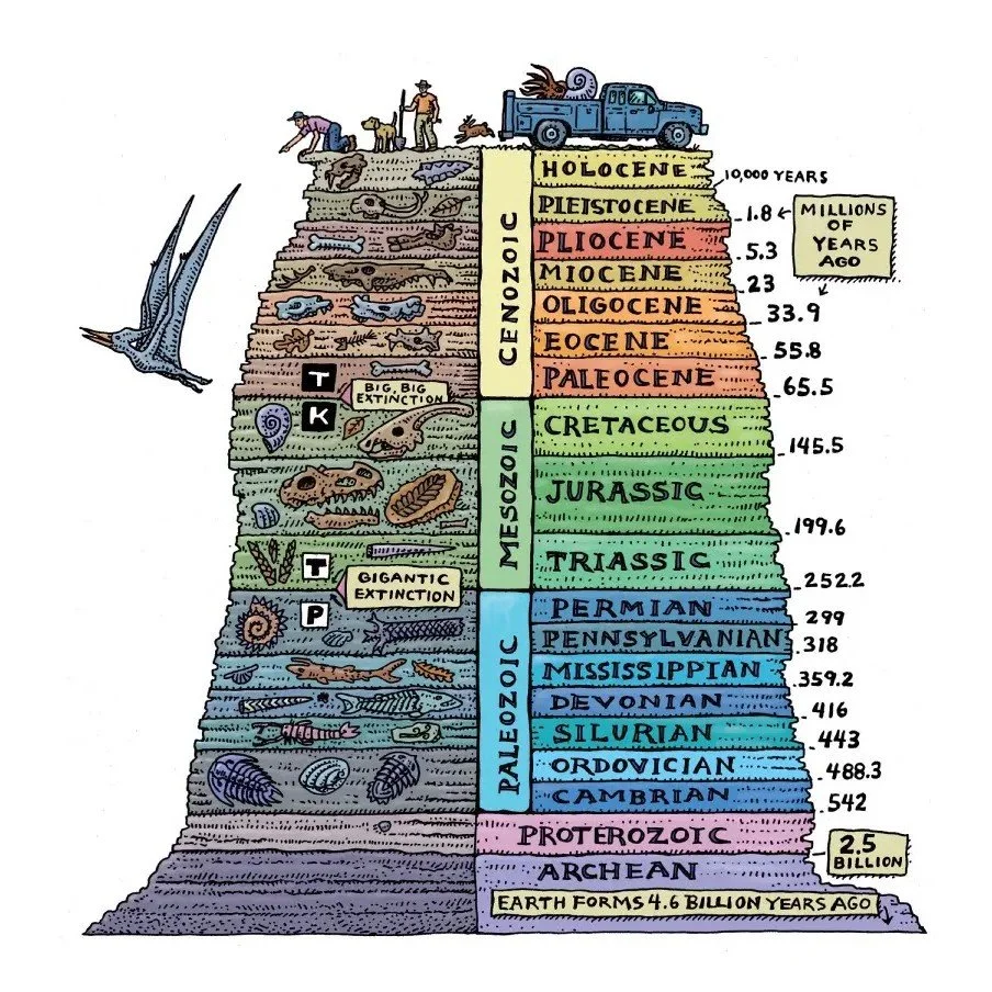
GEOLOGIC TIME
Duration: 90, 120, or 180 minutes
Academic Level: Grades 6–8, 9–12
Overview:
Understanding geologic time is essential
for grasping the vast history of Earth and the processes that
have shaped our planet over billions of years. In this
interactive activity, students use some rope and candy to
explore how geoscientists measure both relative and absolute
time, how the geologic time scale was developed, and the
significance of major events in Earth’s history. Through this,
they begin to appreciate the concept of deep time—the immense
time span of Deep Time.
What to Expect:
Following a lively introduction,
students first engage in activities focused on relative
dating, using concepts such as superposition, cross-cutting
relationships, and fossil succession. They then move on to
explore absolute dating, learning how radioactive decay
functions as a steady natural clock. Students are introduced
to the principles behind radiometric dating, gaining insight
into how geologists assign actual ages to rocks and fossils,
and how these tools are used to build the timeline of Earth’s
dynamic past.

XTREME MAPPING
Duration: 60, 120, or 180 minutes
Academic Level: 9–12
Overview:
In this dynamic and multidisciplinary
activity, students explore topographic mapping, navigation,
and geographic analysis—essential skills used in fields such
as geology, geomatics, engineering, forestry, and environmental
science. Students learn how to interpret and create topographic
maps, explore grid systems, elevation, contour lines, and how
to construct topographic profiles. The activity emphasizes
real-world applications, from measuring the slope of a
mountain to locating earthquake epicentres or hidden
"treasures" in the landscape.
What to Expect:
Session 1 — Field Skills and Traditional Mapping
Techniques: Armed with a topographic map and compass,
students head outdoors to practice essential mapping and
navigation skills. They learn to: Measure distance through
pacing, use a compass to determine a bearing, apply
triangulation using visible landmarks to determine their exact
location on a map, measure distance, height, and slope using
compass-based tools, understand and record strike and dip to
assess slope orientation (for geology-focused learners)
As a culminating field challenge, students put their skills to
the test in a navigation exercise to locate either a series of
"treasures" or an "earthquake epicentre" using triangulation
and observation of real-world topography.
Session 2 — Digital Mapping and Data Analysis with Google
Earth Pro: Back in the lab, students transition to digital
tools using Google Earth Pro to extend and deepen their
mapping experience. They learn to: Calculate distance,
elevation, slope, and area using real satellite imagery,
observe and analyze topographic and environmental changes over
time, and explore real-world case studies (e.g., climate change
impacts, land use, or geological features).
Students finish the session by applying their new skills to
create their own topographic maps. Those with background
knowledge in geology or petrology can go further to construct
geologic maps and profiles, integrating observations about
rock types and structural features.
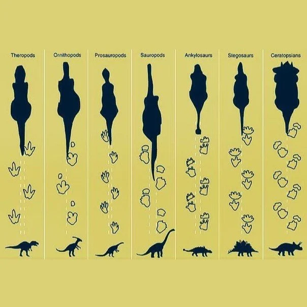
ICHNOLOGY
Duration: 90 or 180 minutes
Academic Level: Grades 7–8, 9–12
Overview:
This hands-on activity introduces upper
middle and high school students to the fascinating field of
ichnology - the study of trace fossils such as footprints,
burrows, and trackways. Unlike body fossils, trace fossils
provide unique insights into the behaviour and movement of
ancient organisms, revealing information that bones alone
cannot.
Students learn to distinguish between body and trace fossils
and investigate how fossilized tracks can be used to
reconstruct past environments and behaviours. By thinking
like paleontologists, students develop critical scientific
skills while exploring how trace evidence helps interpret
life in Earth’s deep past.
What to Expect:
Working in small groups, students
will engage in hands-on activities that include:
- Comparing and classifying body vs. trace fossils.
- Measuring stride length, track size, and track spacing to estimate the gait, speed, and size of the track-maker.
- Reconstructing paleoenvironments and possible behavioural scenarios based on fossil evidence.
- Grappling with the limitations of the fossil record, including the challenge of identifying the species behind a trace.
- Learning about ichnotaxa—classification of trace fossils based on form and inferred behaviour.
- Investigating clues for group movement, changes in direction, predator-prey interactions, or other possible inferences based on the evidence.